| |
BroJon News:
Wednesday November 2, 2005
THE BROJON QUAKE CALCULATOR AND
THE STONEHENGE CONNECTION
Why Does the Earthquake Calculator Work So Well and When Did Mankind First Start Accurately Predicting Earthquakes?
The new updated BroJon Earthquake Calculator
|

fig 1. The BroJon Earthquake Calculator
|
is now posted for the month of November. Also posted just below the
November chart is last month's October chart with the improved
algorithm, showing how accurate the Calculator is at predicting the
timing and magnitudes of world earthquakes during each month. And how
does the Calculator work to predict earthquakes?
The answer is simple. It works exactly the same way Stonehenge,
|
 fig 2. Stone Age Man, typical of Swanscombe or Solutrian Ice Age Man.
 |
on Salisbury Plain in southwest England worked about 6,000 years ago.
Modern scientists, archaeologists and anthropologists, all make the same
mistake in assuming that Stonehenge was some sort of religious temple,
farming calendar, or astronomical observatory. It was, in fact, NONE of
those. There are no alignments, markings nor functions which would
indicate any of those uses.
HOW STONEHENGE ACTUALLY WORKED
Instead, Stonehenge was always only a scientific, massive and accurate
"doomsday" instrument to calculate when disastrous earthquakes and
massive tidal wave tsunamis would occur. At the end of the last Ice
Age, about 10,000 BC, much of England and Europe was covered by
miles-thick glaciers of ice. The world's sea level was much lower then
and there was actually a broad land bridge connecting the British Isles
to Europe. Thus, stone age man could spread their hunter/gatherer
culture around the world, simply by walking from the Mediterranean Sea,
and the middle east, all the way to present day Scotland and Ireland.
About 8,000 BC, as the glaciers receded, the oceans began to rise,
|

fig 3. The
location of Stonehenge in Southern England, just north of the old Land
Bridge between Britain and France, now called the English Channel.
|
and with the much less massive weight on the British Isles, the land
was then free to move. About 7,000 BC, the British Isles began to move
northwest away from Europe, resulting in the opening up of the English
Channel separating England and Europe. The ancient land bridge from
Europe to England began to thin or stretch out and actually dropped
below the sea level.
This separation of Britain from the European continent was not gradual.
It occurred in many repeated large jumps and massive earthquakes over
thousands of years. These massive earthquakes also spawned huge
tsunamis which swept across the low-lands of Belgium and Holland and the
English lowlands or swamplands running from the southern English coast
as far north as Wales. But this was prime and desirable farming and
living territory warmed by the pleasant Gulf Stream currents. The
desperate stone age "problem" then was to figure out how to predict the
frequent massive earthquakes and tsunamis which could completely
devastate the cultures of western Europe at the end of the last Ice Age.
SOLVING THE "DISASTER" PROBLEM
It didn't take long for the stone age "scientists" to observe that the
earthquakes and tsunamis only occurred when the moon was at its most
northern or southern extremes, above and below the earth's equator.
|
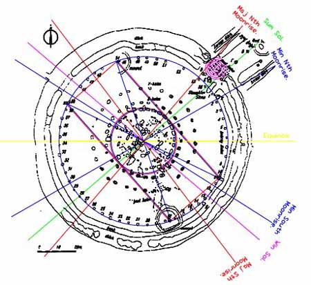 fig 4. Layout of Stonehenge showing the extremes of the setting sun and moon
|
Knowing this, and then simply by observing the motions of the moon and
sun would allow the stone age Europeans to predict when the massive
earthquakes and tsunamis would occur. This was an early ancient
"tsunami" warning system. Simply by knowing when the moon would
approach an extreme north or south position would allow the stone age
inhabitants to temporarily travel to much higher ground and thus escape
the impending doomsday disaster.
The proof that this was, in fact, the function of Stonehenge is shown
by the fact that the alignments of the five central massive trilithons
in the middle of Stonehenge only line up with the extremes of the sun or
"solstices" and the extremes of the moon or "lunastices."
The extremes of the moon do occur twice each month, but these are mostly
monthly "minor lunastices." Because of the variations of the shape and
tilt of the moon's orbit, about every 18.5 years, only then does the
moon move to its most extreme north and south motion, or "major
lunastice," of 28 degrees above and below the motion of the sun. And
that is the most dangerous time for the massive devastating earthquakes
and tidal waves.
A recent example is the Indonesian Tsunami Quake which killed 90,000
people. This occurred at the Winter Solstice when the sun was at its
most southern extreme, and on the same day when the moon was at its most
northern extreme Lunastice of 28.5 degrees on December 26, 2004.
THE EARLY SCIENCE IN THE STONES
All of these numbers and angles are marked by the stones at Stonehenge.
There seem to be no other markings or alignments to indicate Stonehenge
was ever used for observing stars or as an astronomical observatory,
nor are there any alignments for the solar "equinoxes" which are used
for making accurate calendars for farming and agriculture. Thus
Stonehenge was always only an 8,000 year old earthquake disaster
predictor.
If you wanted to build an early scientific instrument for predicting the
times of the twin disasters of massive earthquakes and tsunamis, how
would you build it?
|
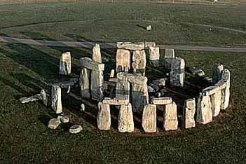
fig 5. Despite the slightly sloping ground, the lintels atop
the large outer ring are all perfectly level, making a perfect
"artificial horizon" above the distant trees and hills of the real
horizon. This allowed for consistent sighting of the setting and rising
sun and moon through the five massive central Trilithons, which are
lined up with the extremes of the sun and moon.
|
For your scientific instrument to safely survive the very same
disasters it was designed to predict, you would need to make it "very
big and very heavy." Or else it would be simply knocked down or washed
away. This is probably what happened to the first and oldest versions
of Stonehenge which have since disap- peared. And, of course, "big and
heavy" is the first thing you notice about what makes Stonehenge a
unique and permanent scientific stone age instru- ment dating from about
6,000 BC.
THE IMPORTANT REASON FOR BUILDING STONEHENGE
The instrument was necessary for the continued existence of the many
cultures living in northwestern Europe just after the last Ice Age.
"Continued existence" is a strong motivation for humans to travel from
many hundreds of miles around Salisbury Plain to volunteer to work on
the huge lunar instrument. The purpose for building Stonehenge was
"basic survival" and it was not some "religious belief" or supersticious
motivation. Stonehenge was built about 4,000 years before the arrival
of any Celts or Druids. So the Druids did not design nor build it.
Which is why modern-day neo-Druids have no clue as to what Stonehenge
was for, nor how the scientific instrument was used.
And now you know, why the Brother Jonathan Gazette Earthquake Calculator
works as well, and as accurately as it does. I simply turned the
alignments of the ancient Stonehenge stones into a computer program. I
can run the computer program into the past to confirm predictions with
past actual earthquake records. Or I can run the program into the
future and publish the predictions in the BroJon Gazette. I use a
computer to travel through time. The ancient unknown stone age builders
of Stonehenge could do pretty much the same thing, simply by counting
around the outer ring of smaller blue Sarcen Stones and Aubrey holes,
something like a Lunar Abacus.
THE SCIENTIFIC EVIDENCE PROVING STONEHENGE IS AN EARTHQUAKE DISASTER PREDICTOR
Is there any scientific evidence to show that what I just explained to
you is true? Actually there is. Several decades ago archaeologists
discovered a mysterious stone age village, apparently inhabited by a
group called Swanscombe Man.
|

fig
6.
A recent NASA photograph showing a lunar eclipse between the stones.
Lunar and Solar eclipes occur when both the sun and the moon are near
the equator and not near an extreme solstice or lunastice angle. No
earthquake occurred at this time. This "astronomical" observation was
not the function of Stonehenge
|
What was mysterious about the village was its location -- many miles
offshore from Holland and about 100 feet below the sea level in the
English Channel. What is a stone age village doing in the middle of
the English Channel, between England and Holland, and why did it sink
below the ocean? Obviously, at one time that region of the English
Channel was a land bridge above sea level during the late Stone Age when
the village was built.
Is it possible that there actually are more Swanscombe villages still
yet undiscovered on the ancient land bridge between England and France?
Is it possible that the Swanscombe culture actually had many villages
and even larger towns and circular cities in that rich green fertile
region on the land bridge? Could it be that this ancient culture which
spread across the land bridge from Europe to the British Isles about
6,000 BC is the source of the ancient legend of Atlantis?
Certainly a culture which built towns and cities on the old stone age
land bridge eight thousand years ago, would be exactly where Plato's
Atlantis story says it was, beyond the Pillars of Hercules, in the
Atlantic Ocean and then mysteriously and suddenly, it sank below the
waves. But what about those "very advanced" Atlanteans? Was the
stone age Swanscombe land-bridge culture "advanced" enough to be the
lost Atlanteans? Well, they were advanced enough to know how, why and
where to build the huge circular scientific instrument called
Stonehenge. And then smart enough to figure out how to use it. Need I
say more?
Marshall Smith
Editor, Brother Jonathan Gazette
newseditor@brojon.com
COMING NEXT IN PART 2 ...
The
new archaeological evidence for an advanced human culture which built
boats and sailed the world as early as 40,000 BC. The recently
discovered evidence for the advanced culture in Europe during the last
Ice Age, 17,000 BC which later built Stonehenge and also hundreds of
"woodhenges" across Europe and North America. Was this the culture
which was later mis-identified as the Atlanteans?
Also
the recent evidence which shows the adept skills of this Ice Age
culture with knowledge of astronomy, mathematics and navigation. They
almost discovered the absolute value of "pi" as shown in the hundreds of
"nearly" circular burial mounds in Europe and North and South America.
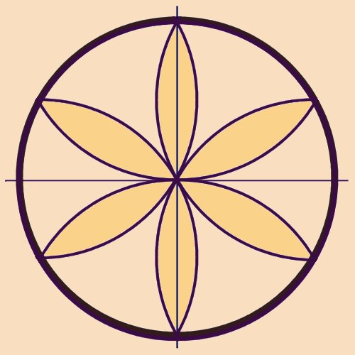
Also, we'll find out about the very first Stone Age
intellectual discovery about 15,000 BC, which marked man as a thinking
conscious being. And it only used man's most basic tool -- his thumb
and forefinger. It was the discovery of how to make a perfect circle,
perfectly divided into exactly six parts. This was the basis for all
modern mathmatics, and the "measure" or division of the reality of all
time and space into 6, 12, and 24 hours -- and the "measure" or dividing
of all space into 360 degrees.
This first and most basic human intellectual "discovery" has been in
use continuously by all humans throughout the world for over 6,000 years
and it is still used unchanged today. You just never knew how and
where it came from. And I'll show you that this "circle of 6" is also
the basic layout plan for Stonehenge. It is also the scientific
mathematical reason for "the measure of man is 666." And even the
reason for "the six days of creation" and why quarks always come in
threes. That is all coming next.
-- BROTHER JONATHAN GAZETTE
| |